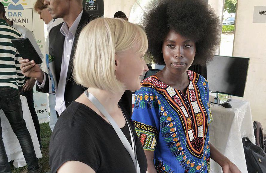
(Image) Our team joins the annual GIS Day of Tanzania each year. During the day geospatial and ICT actors from Tanzania and beyond get together to share news of the sectors’ progress.
Title | Geospatial and ICT capacities in Tanzanian Higher Education Institutions (Geo-ICT) |
Year | 2017-2019 |
Leader | UTU Geography and Future Technologies (N.Käyhkö, V. Leppänen) |
Funding | MFA/HEI-ICI |
The project is implemented by the University of Turku (UTU) with four Tanzanian HEIs: University of Dar es Salaam (UDSM), Ardhi University (ARU), State University of Zanzibar (SUZA) and Sokoine University of Agriculture (SUA).
Tanzanian academic institutions’ attention is currently drawn to issues of quality and relevance of geospatial and ICT research and education, since societal needs call for their urgent attention. Despite the fact that geospatial and ICT expertise is constantly increasing in HEIs, and in the society in general, universities still have a lack of skilled staff and up-to-date research environments. Thus, HEIs are unable to transform geospatial and ICT skills to benefit their students at the practical level and further to benefit the society at large. Tanzanian HEIs who are currently putting their strategical and practical efforts into improvement of these skills are in need of support and partnerships, which can help them to steer the expertise into sustainable trajectories.
This HEI-ICI project, Geospatial and ICT capacities in Tanzanian Higher Education Institutions (Geo-ICT) is focusing on two HEI-ICI result areas: improving the quality of higher education and research environment (Result area 2) and strengthening the role and relevance of HEIs in development of the society (Result area 4).
Our key activities include: improving the skills and pedagogical competence of staff (output 2.1), renewing teaching structures and materials (output 2.2) and upgrading research and education environment with key infrastructures (output 2.3). These qualities are foundation for the prosperity of Tanzanian geospatial and ICT expertise. Secondly we will improve stakeholder networks and collaboration modalities of HEIs (output 4.1) and introduce HEIs with relevant and catalysing role in the innovation realization and entrepreneurship support for the emerging geospatial/ICT business sector in Tanzania (output 4.2). Our key activities include: review and planning of the capacity development, intensive and distant GIS/ICT/pedagogical training and extended professional research/study visits, upgrading and renewing existing environment and establish new resources, planning, organizing and implementing various stakeholder activities and constructing a strategy and implementation plan for HEIs role in the future entrepreneurship ecosystem in Tanzania.
At the end of the 3-year project, the quality and societal relevance of Geospatial and ICT research and education in four Tanzanian HEIs is improved. Teaching and research staff is more competent in geospatial and ICT skills, and more capable of tackling with environmental and social problems in Tanzania, the contents and methods of teaching are improved and research environments in GIS/ICT are improved and existing ones more effectively used (Result Area 2 improvements).
There is increased synergy and interdependence among HEIs and their stakeholders in GIS/ICT expertise and its uses in the society, and HEI’s have improved modes of collaboration with the public, private and civil society actors. HEIs act as catalysts for GIS/ICT business ecosystem development and graduates are more skilled actors in the private sector (Result Area 4 improvements). In the long-run this means that GIS/ICT experts are more abundantly available for public and private sector employment solving environmental and societal problems in Tanzania and East Africa. Tanzanian HEIs are respected and valued expert institutions and they influence societal development in the sector of geospatial/ICT solutions and support government decisions the implementation of related policies and practices. Entrepreneurship in the sector of geospatial (GIS/ICT) business is increased and diversified and brings economic benefits to Tanzanian society.