Throughout 2017 UTU Tanzania team co-developed a practitioners’ manual on participatory mapping tools for official village land use planning in Tanzania. Finally early this April the manual was presented and refined in a three-day stakeholder workshop. The workshop gathered together over 40 Tanzanian land use planning actors among them academia, authorities and NGOs. It was an inspiring forum for sharing experiences on the use of simple spatial technologies to support active community engagement and production of high quality land use plans at village level. We are expecting to publish the manual by the end of the year in order for more practitioners to take advantage of the tools in Tanzania.
The development of the planning tools and the manual has been a joint effort together with the National Land Use Planning Commission of Tanzania and Private Forestry Programme of Ministry of Foreign Affairs of Finland and Ministry of Natural Resources and Tourism of Tanzania.
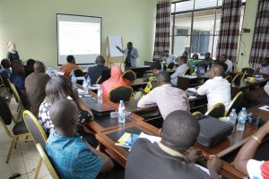
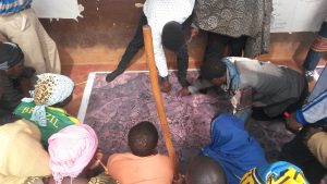
(Image left) The Director General, Dr. Stephen Nindi, of the National land Use Planning Commission addresses the stakeholder workshop participants in Morogoro. (Right) Participatory mapping tool in use during land use planning in one of our collaboration villages.